Social Sciences
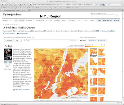 Who's renting Twilight? via NY Times
Here's yet another fascinating use of GIS technology. (I blogged about free GIS applications in a previous post.) This technology is even more powerful when a teacher can reference popular culture for "educational purposes." For example, check out this NY Times article that provides interactive maps detailing Netflix users' DVD queues via GIS technology. Interactive city maps include New York, Boston, Chicago, Washington, Bay Area (e.g., San Francisco), L.A., Seattle, Minneapolis, Denver, Atlanta, Dallas, and Miami. A great use of these maps is having students compare rental patterns (e.g., Twilight, Milk, Taken, Doubt) to Census demographics presented through gCensus and Google Earth. That is, what variables seem to attribute to the high number of Twilight rentals in certain neighborhoods? Number of teenage children or number of single adults? Ok, kidding aside (I should actually see the movie before I criticize it), this article is a great example of how map analysis (with a pop culture spin) and GIS can be made even more accessible in the classroom.
- New Release - U.s. Census Bureau International Population Data And Maps
From my colleague Joshua Comenetz at the Census Bureau--fascinating data! The Census Bureau has added to and updated the online collection of subnational population data linked to maps (shapefiles) that are available at the Spatial Data Repository. The...
- Teaching Current Events? There's A (gis) Map For That...
I continue to be amazed with the amount of (free) resources available for introducing students to (and engaging them with) GIS. If you want a quick overview of what GIS is and how it relates to geography, consider this video. You can also click on the...
- More Gis
I've admittedly been away from my posting for too long, and the number of amazing resources out there continues to proliferate. I have a lot of catching up to do, so here's a start... Let's talk about Geography Geography is not memorizing...
- Free Gis With Google Earth
Recently, I've been learning how to use GIS software, namely ArcGIS, to figure out more ways to include these tools in my methods courses. I agree with the literature that--in terms of pubic school curricula--this powerful tool takes Geography beyond...
- See The World Via Worldmapper
Land Area via Worldmapper Extinct Species via Worldmapper Worldmapper is a great site to help students visualize basic statistical data about the world. Go to the "Map Categories" section to find the various types of maps available, including categories...
Social Sciences
Netflix Queues via GIS
Who's renting Twilight? via NY TimesHere's yet another fascinating use of GIS technology. (I blogged about free GIS applications in a previous post.) This technology is even more powerful when a teacher can reference popular culture for "educational purposes." For example, check out this NY Times article that provides interactive maps detailing Netflix users' DVD queues via GIS technology. Interactive city maps include New York, Boston, Chicago, Washington, Bay Area (e.g., San Francisco), L.A., Seattle, Minneapolis, Denver, Atlanta, Dallas, and Miami. A great use of these maps is having students compare rental patterns (e.g., Twilight, Milk, Taken, Doubt) to Census demographics presented through gCensus and Google Earth. That is, what variables seem to attribute to the high number of Twilight rentals in certain neighborhoods? Number of teenage children or number of single adults? Ok, kidding aside (I should actually see the movie before I criticize it), this article is a great example of how map analysis (with a pop culture spin) and GIS can be made even more accessible in the classroom.
- New Release - U.s. Census Bureau International Population Data And Maps
From my colleague Joshua Comenetz at the Census Bureau--fascinating data! The Census Bureau has added to and updated the online collection of subnational population data linked to maps (shapefiles) that are available at the Spatial Data Repository. The...
- Teaching Current Events? There's A (gis) Map For That...
I continue to be amazed with the amount of (free) resources available for introducing students to (and engaging them with) GIS. If you want a quick overview of what GIS is and how it relates to geography, consider this video. You can also click on the...
- More Gis
I've admittedly been away from my posting for too long, and the number of amazing resources out there continues to proliferate. I have a lot of catching up to do, so here's a start... Let's talk about Geography Geography is not memorizing...
- Free Gis With Google Earth
Recently, I've been learning how to use GIS software, namely ArcGIS, to figure out more ways to include these tools in my methods courses. I agree with the literature that--in terms of pubic school curricula--this powerful tool takes Geography beyond...
- See The World Via Worldmapper
Land Area via Worldmapper Extinct Species via Worldmapper Worldmapper is a great site to help students visualize basic statistical data about the world. Go to the "Map Categories" section to find the various types of maps available, including categories...