Social Sciences
Here are a few additional geography resources of note.
In a previous post, I mentioned the National Geographic Xpeditions site, which is a great spot to find lessons and print-friendly maps. Another place to get maps, including "Maps with Historical Themes" (e.g., Silk Road, Moundbuilder sites in the U.S.) is under the "Maps" tab (on the left-hand side of the homepage) from the Arizona Geographic Alliance site.
Another quick link to resources is Education World's "Great Sites" for map-related activities.
Teachnology also archives great lesson ideas, including the Edible State Map Lesson Plan (including the recipe).
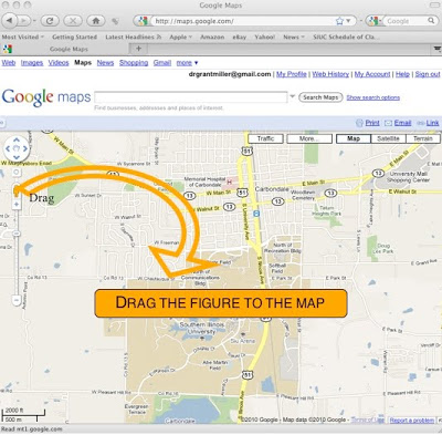
 via Google Maps
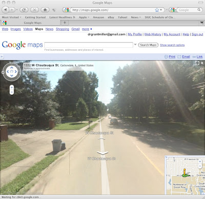
Finally, don't forget about the myriad features via Google Maps (I talk about Google Earth and gCensus in a previous post). For example, when teaching younger students the differences between horizontal and bird's eye views, that little "yellow figure" can be dragged to any location for a street-level view of most communities.
 Street-level image (once figure is dragged to map) via Google Maps
- New Release - U.s. Census Bureau International Population Data And Maps
From my colleague Joshua Comenetz at the Census Bureau--fascinating data! The Census Bureau has added to and updated the online collection of subnational population data linked to maps (shapefiles) that are available at the Spatial Data Repository. The...
- Teaching Current Events? There's A (gis) Map For That...
I continue to be amazed with the amount of (free) resources available for introducing students to (and engaging them with) GIS. If you want a quick overview of what GIS is and how it relates to geography, consider this video. You can also click on the...
- More Gis
I've admittedly been away from my posting for too long, and the number of amazing resources out there continues to proliferate. I have a lot of catching up to do, so here's a start... Let's talk about Geography Geography is not memorizing...
- Netflix Queues Via Gis
Who's renting Twilight? via NY Times Here's yet another fascinating use of GIS technology. (I blogged about free GIS applications in a previous post.) This technology is even more powerful when a teacher can reference popular culture for "educational...
- See The World Via Worldmapper
Land Area via Worldmapper Extinct Species via Worldmapper Worldmapper is a great site to help students visualize basic statistical data about the world. Go to the "Map Categories" section to find the various types of maps available, including categories...
Social Sciences
More Geography Resources
Here are a few additional geography resources of note.
In a previous post, I mentioned the National Geographic Xpeditions site, which is a great spot to find lessons and print-friendly maps. Another place to get maps, including "Maps with Historical Themes" (e.g., Silk Road, Moundbuilder sites in the U.S.) is under the "Maps" tab (on the left-hand side of the homepage) from the Arizona Geographic Alliance site.
Another quick link to resources is Education World's "Great Sites" for map-related activities.
Teachnology also archives great lesson ideas, including the Edible State Map Lesson Plan (including the recipe).
 via Google Maps
 Street-level image (once figure is dragged to map) via Google Maps
- New Release - U.s. Census Bureau International Population Data And Maps
From my colleague Joshua Comenetz at the Census Bureau--fascinating data! The Census Bureau has added to and updated the online collection of subnational population data linked to maps (shapefiles) that are available at the Spatial Data Repository. The...
- Teaching Current Events? There's A (gis) Map For That...
I continue to be amazed with the amount of (free) resources available for introducing students to (and engaging them with) GIS. If you want a quick overview of what GIS is and how it relates to geography, consider this video. You can also click on the...
- More Gis
I've admittedly been away from my posting for too long, and the number of amazing resources out there continues to proliferate. I have a lot of catching up to do, so here's a start... Let's talk about Geography Geography is not memorizing...
- Netflix Queues Via Gis
Who's renting Twilight? via NY Times Here's yet another fascinating use of GIS technology. (I blogged about free GIS applications in a previous post.) This technology is even more powerful when a teacher can reference popular culture for "educational...
- See The World Via Worldmapper
Land Area via Worldmapper Extinct Species via Worldmapper Worldmapper is a great site to help students visualize basic statistical data about the world. Go to the "Map Categories" section to find the various types of maps available, including categories...
